NA-POPS

Point Count Offsets for Population Sizes of North American Landbirds

Find Out More

About

Our goal is to generate open-source detectability offsets for all species of landbirds in North America. These offsets will allow the quantitative integration of observations from different programs and field protocols (e.g., integrating observations from the North American Breeding Bird Survey with stationary counts from eBird). We are working to compile existing datasets of point counts conducted using field protocols that allow for distance sampling (Marques et al. 2011) and/or removal-model (Farnsworth et al. 2002) based estimates of detectability. We aim to compile data representing the broadest possible array of species and field conditions from across North America. NA-POPS will contribute to improved estimates of continental and regional population sizes and population trends, and be useful for countless conservation, management, and research applications. We will, of course, provide recognition for the data contributions that will make this work possible and formal acknowledgments in the resulting products.

Collaborators

We are currently a team of 19 researchers from several organizations across North America, including:

Boreal Avian Modelling Project

Carleton University

Environment and Climate Change Canada

University of Minnesota

National Audubon Society

Natural Resources Canada

Minnesota Department of Natural Resources

Klamath Bird Observatory

United States Geological Survey

Bird Conservancy of the Rockies

Data Contributors

We are deeply grateful for data contributions from the following organizations and individuals:

Avian Knowledge Network, Boreal Avian Modelling Project, Integrated Monitoring in Bird Conservation Regions, Barry Robinson, Klamath Bird Observatory, Nature Counts, National Ecological Observatory Network, Daniel Twedt, United States Forest Service, WildTrax, Minnesota Breeding Bird Atlas, Tidal Marsh Monitoring Project

Publications

Edwards BPM, Smith AC, Docherty TDS, Gahbauer MA, Gillespie CR, Grinde AR, Harmer T, Iles DT, Matsuoka SM, Michel NL, Murray A, Niemi GJ, Pasher J, Pavlacky Jr. DC, Robinson BG, Ryder TB, Sólymos P, Stralberg D, Zlonis EJ. (2022). Point Count Offsets for Estimating Population Sizes of North American Landbirds. Ibis ibi13169. https://doi.org/10.1111/ibi.13169

Contribute

Field Protocols

Point counts conducted using field protocols that allow for distance sampling (Marques et al. 2011) and/or removal-model (Farnwsworth et al. 2002) based estimates of detectability. The data must be in a format that allows us to estimate the removal and/or distance sampling components, i.e., they must retain the time of observation and/or distance to bird. Our approach can handle both continuous measures of time or distance, or binned-intervals or time or distance, and any combination of time and distance. Even point count data that only include observations of birds separated into two distance bands (e.g., <50m and >50m) or two time intervals (e.g., 1-3 minutes and 3-5 minutes) are useful. Ancillary info

Ancillary Information

Each point count event must also have associated information on:

Spatial X-Y Coordinates

Date of Observation

Start Time

End Time

Additional info on surrounding habitat (e.g., forested, open-area, etc.) or observation conditions (e.g., roadside count) are useful, but not necessary.

Roadside and Offroad Surveys

We have a particular interest in estimating detectability offsets that will allow for the integration of roadside counts (e.g., Breeding Bird Survey counts) with off-road counts (e.g., IMBCR, Atlasses, and eBird). For this goal, we need large numbers of counts in both roadside and off-road conditions.

Geographic Coverage

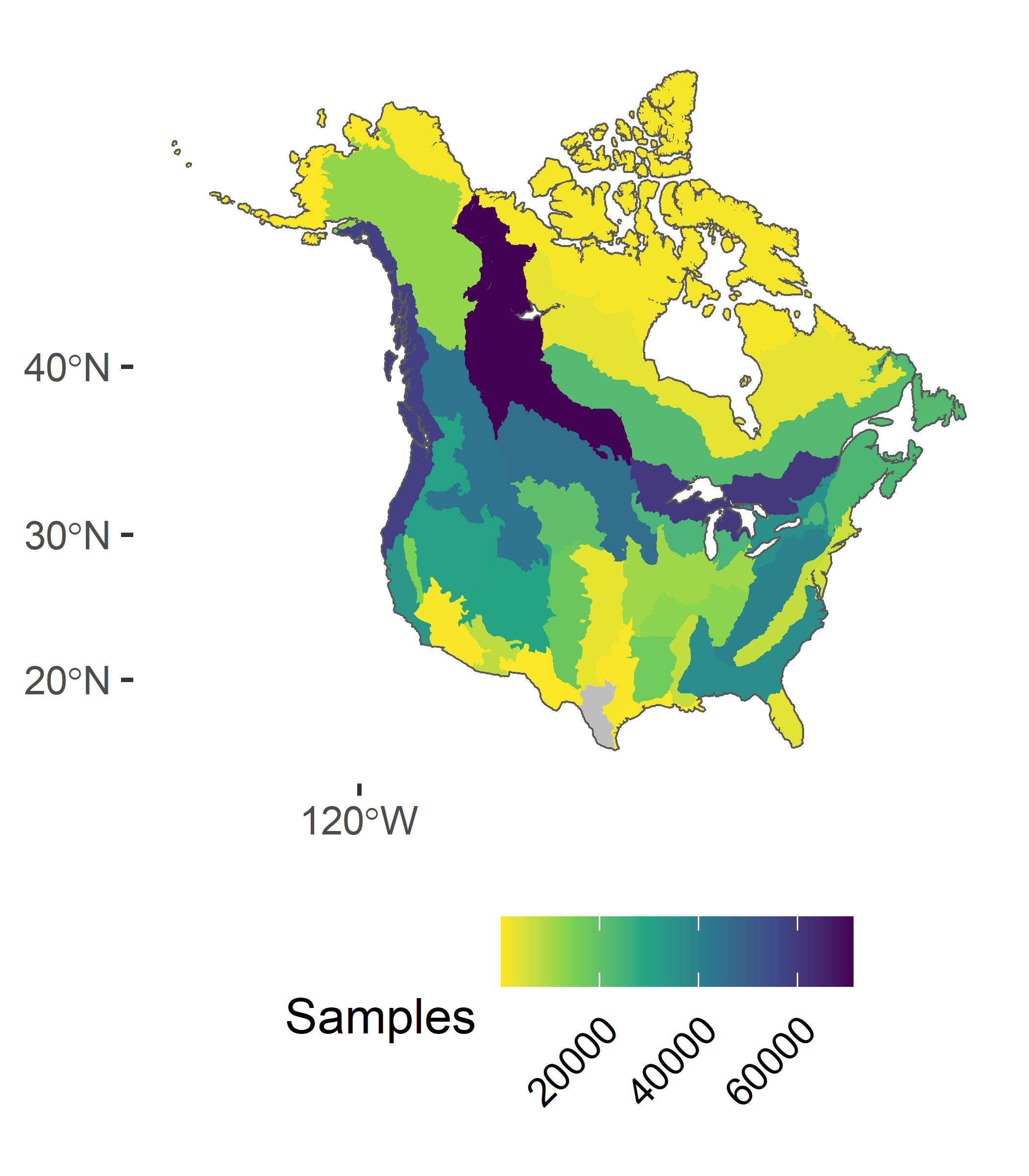
To date, we have observations covering much of North America, but there are some notable gaps in our coverage in the Southern United States, the far north, and Mexico (Yellow and Gray areas).

Data use and security

Our project goals are fundamentally open-data and open-source. We aim to create a public resource for use in broad-scale population estimation and monitoring, and for countless research, conservation, and management applications. Many of the data contributed to this project will already be publicly available. Private data can also contribute to the project without being made public, through our hierarchical structure of mixed public and private GitHub repositories. We encourage the use of permissive licenses, such as Creative Commons for data and text, open-source (GPL or MIT) to establish a transparent workflow, and also clearly stating intellectual contributions. The project’s GitHub organization will also house all of the open-source code, results, and documentation for users.

Want to see some interactive results?

Visit Dashboard (new tab)